A deep freeze had clenched the Boise valley for weeks and snow lay thick on the foothills. In mid-January the temperature shot up to a balmy 50 degrees and rain began to fall. Day after day the rain continued. On January 21, 1866, according to the January 23, 1866 edition of the Idaho Tri-Weekly Statesman, “Cottonwood Creek came out of its bed and appropriated the whole of Main street to the depth of six to twelve inches.”
Luckily for the approximately 800 people that lived in Boise in 1866, the floodwaters were kept out of most of the Main St. cellars. But Cottonwood Creek continued to be a “great source of trouble and expense.” Winter rain-on-snow storms, spring freshets, and heavy summer downpours caused the creek to rise precipitously and follow the path of least resistance down 6th Street to Main Street to the Boise River.
The Fort, the City and the Creek
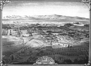
In July 1863, the U.S. Army established Fort Boise on a slight rise overlooking Cottonwood Creek. It appears that the nation’s river experts, the Army Corps of Engineers, were busy elsewhere and did not participate in the decision on where to locate the Fort. The low-lying part of the Fort was built in the path of Cottonwood Creek.
Not long after this, in August 1863, Boise City founders laid out a townsite about a half-mile away. The initial plat was for ten blocks on each side of Main Street between 5th Street and 10th Street. Fort Boise and Cottonwood Creek were thought to be a good distance away, but actually the channel of the creek cut diagonally through the townsite. During the periods when the creek flow was low or non-existent there were no problems, but when the waters rose, Cottonwood Creek made a beeline for Main Street. So began an expensive battle against the floodwaters and this battle continues to the present day.
8,000 Acres and 3,000 Feet
Cottonwood Creek is the largest tributary to the lower Boise River. It drains an 8,000‐acre watershed of the Boise Front, northeast of downtown Boise. The headwaters of Cottonwood Creek are at 5,600 feet elevation, nearly 3,000 feet above Fort Boise. The watershed was heavily grazed in the late 1800’s and many mines were dug in the upper reaches.
“Quite an excitement prevailed”
By 1881, the population of Boise had more than doubled and the battle with Cottonwood Creek escalated.
As reported by the Idaho Tri-Weekly Statesman on February 3 and 5, 1881, incessant rains on the snow-covered foothills “caused such a rushing of the waters from the melted snow on the lower slopes of the mountains that all the small streams have been swollen into rivers.” Cottonwood Creek “came sweeping down through the outskirts of the town into Sixth street, and thence into Main street at the Statesman office. In a few minutes these streets were flooded; many residences were surrounded by water, and quite an excitement prevailed.”
An army of towns folk jumped into action “to check the rushing of the flood down Main street.” The US Army at Fort Boise also sprang into action, but the newspaper reported the water “baffled them and found its way out of the proper channel.” The newspaper office was located on Sixth Street and the reporter had a front row seat to watch “the torrent again rushing down Sixth and Idaho streets, and threatening every moment to break the temporary embankment that had been thrown across Main street at the crossing of Main and Sixth. The streets were soon filled with men rushing hither and thither with lanterns, and every possible effort was made to keep the water in its passage down Sixth street.”
“Considerable Damage Was Done”
The rain continued into the next day and despite a force of 50 men mustered by the Mayor to work on the dam at Fort Boise, Cottonwood Creek “suddenly rose some two or three feet.” The temporary dams at 6th and Main, “gave away and the water took its coveted way again down Main street. Many residences were surrounded by water to the great discomfort of the inmates, and considerable damage was done to property by the flooding of cellars, and compelling the removal of carpets and other furniture.”
Cottonwood Creek continued to flow through the eastern part of Boise well into March 1881. On July 30, 1881 the Idaho Tri-Weekly Statesman editor wrote, “This creek has been a great source of trouble and expense to Boise City.” The City Council was moved to action. On September 22, 1881 an advertisement appeared in the Idaho Tri-Weekly Statesman stating the City was accepting bids for the construction of a stone flume on Cottonwood Creek.
Part I of a blog series exploring the history of Cottonwood Creek. Made possible by the Idaho Fish and Wildlife Foundation and the Boise River Enhancement Network.
The Cottonwood Creek Daylighting Project
The Boise River Enhancement Network is a partner in a cooperative project to ‘daylight’ Cottonwood Creek where it flows through Julia Davis Park and enters the Boise River. The creek currently runs through a stone flume under the park. A new open creek channel will be constructed for the creek benefiting fish and wildlife, water quality and park visitors, and the flume will be ‘retired.’ The project leads are City of Boise and Trout Unlimited. Partners include the Intermountain Bird Observatory, Ada County Highway District, Golden Eagle Audubon Society, and Land Trust of the Treasure Valley. The project is funded, in part, by the US Bureau of Reclamation, the City of Boise Open Space and Clean Water Fund, and the Idaho Fish and Wildlife Foundation.